bicyclist
Guest
OK, I'll start. Post great riding roads with road number, location and a pic if you have one. The idea is to post specific roads that you know to be outstanding so that others can research them for future rides.
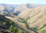
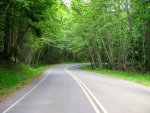
Rattlesnake Grade, Rt 129 in western Washington.
https://www.google.com/maps/dir/Oregon+3+&+Buford+Ridge+Rd,+Enterprise,+OR/Fields+Spring+State+Park,+992+Park+Rd,+Anatone,+WA+99401/@46.015742,-117.2465837,13z/data=!4m13!4m12!1m5!1m1!1s0x54a17721e0a49a0f:0x51ecd72e3386246e!2m2!1d-117.2724065!2d45.9444037!1m5!1m1!1s0x54a1a1b600ad42b1:0x66996f05f393bf33!2m2!1d-117.166743!2d46.080077
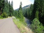
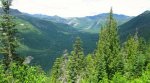
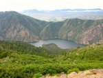
NF 39 from the Snake River over the Wallowa Mountains to near Joseph, OR.
https://www.google.com/maps/dir/Oregon+86+&+N+Pine+Rd,+Halfway,+OR+97834/Joseph,+OR+97846/@45.141873,-117.0736843,11z/data=!4m13!4m12!1m5!1m1!1s0x54a436df1d594b91:0xc863b3ba5d405e83!2m2!1d-116.9511834!2d44.910075!1m5!1m1!1s0x54a406ae5f1023d1:0x6fe3bd580be5f73c!2m2!1d-117.2296126!2d45.3543187
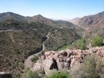
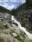
Devil's Highway, Rt 191 in eastern Arizona from Clifton to Alpine.
https://www.google.com/maps/dir/Alpine,+AZ/Clifton,+AZ/@33.3980971,-109.3730412,10z/data=!4m19!4m18!1m10!1m1!1s0x87264861b59e65bf:0xdd97ef267290367c!2m2!1d-109.1432936!2d33.8483212!3m4!1m2!1d-109.3717221!2d33.4189419!3s0x8727c4b7f1825b03:0xa6c7f220891d8ce5!1m5!1m1!1s0x8727ebdacba7bb4b:0x847b751957033a61!2m2!1d-109.2961826!2d33.0508966!3e0
Rattlesnake Grade, Rt 129 in western Washington.
https://www.google.com/maps/dir/Oregon+3+&+Buford+Ridge+Rd,+Enterprise,+OR/Fields+Spring+State+Park,+992+Park+Rd,+Anatone,+WA+99401/@46.015742,-117.2465837,13z/data=!4m13!4m12!1m5!1m1!1s0x54a17721e0a49a0f:0x51ecd72e3386246e!2m2!1d-117.2724065!2d45.9444037!1m5!1m1!1s0x54a1a1b600ad42b1:0x66996f05f393bf33!2m2!1d-117.166743!2d46.080077
NF 39 from the Snake River over the Wallowa Mountains to near Joseph, OR.
https://www.google.com/maps/dir/Oregon+86+&+N+Pine+Rd,+Halfway,+OR+97834/Joseph,+OR+97846/@45.141873,-117.0736843,11z/data=!4m13!4m12!1m5!1m1!1s0x54a436df1d594b91:0xc863b3ba5d405e83!2m2!1d-116.9511834!2d44.910075!1m5!1m1!1s0x54a406ae5f1023d1:0x6fe3bd580be5f73c!2m2!1d-117.2296126!2d45.3543187
Devil's Highway, Rt 191 in eastern Arizona from Clifton to Alpine.
https://www.google.com/maps/dir/Alpine,+AZ/Clifton,+AZ/@33.3980971,-109.3730412,10z/data=!4m19!4m18!1m10!1m1!1s0x87264861b59e65bf:0xdd97ef267290367c!2m2!1d-109.1432936!2d33.8483212!3m4!1m2!1d-109.3717221!2d33.4189419!3s0x8727c4b7f1825b03:0xa6c7f220891d8ce5!1m5!1m1!1s0x8727ebdacba7bb4b:0x847b751957033a61!2m2!1d-109.2961826!2d33.0508966!3e0
Attachments
-
 98.7 KB Views: 25
 -
 96.2 KB Views: 24
 -
 97.9 KB Views: 26
Last edited by a moderator:
 (Just yankin' your chain, Phil. Most people make the name plural.)
")