Larry Hull, the guy I've mentioned and I finally got a chance to ride together today. We met at McDonald's. Our scheduled meeting time was 8:30 and I was there at 8:15 (take note, junglejim!) When Larry walked in, he was astonished that I was there. He said that he had never met anyone who got there before he did. We had breakfast and hit the road (US-34) west. Once we got through the traffic in Loveland, we were behind a motor home as we went up the Big Thompson Canyon. But he kept moving pretty well and we weren't able to pass him till we were five miles from Estes Park. For some reason the south entrance to Rocky Mountain National Park was closed so we went to the north entrance. When we got there, there were about 10 pickups pulling trailers in one of the payment lines. The other one had a car and a van, so I led us into that line.
Know how to stop a line from moving? Put me in it. All ten of the vehicles in the long line got in before we did, plus another line opened up just as we got to the ticket booth.
It didn't hurt anything, because we were through most of the traffic pretty quickly. When we got up to Many Parks Curve, the speed limit was down to 35mph and there was an occasional driver doing 25, but the scenery made it easy to poke along. By the time we got past Rainbow Curve and above tree-line, we were able to run 35 (plus a couple or three miles-per-hour) until we were past the Alpine Visitors Center, which is just a few miles past the high point of Trail Ridge Road, which was, IIRC, 12,210'. The road through the park has been freshly repaved and was a wonderful ride. After we got through the Park, we rode to Granby, and hopped onto US-40, but only for a few miles till we turned north on CO-125, the road to Rand and Walden. 125 is a great road, with sweepers that can be comfortably ridden at 50-60mph speeds. There's an occasional tighter turn that keeps you on your toes until you get to Jackson County a few miles past Willow Creek Pass. Then the road straightens out and has rollers with ranches on the west side and forests on the east side.
Rand is a tiny town with a post office and a General Store and the Rand Yacht Club (which is an occasionally-open eatery. Parked next to the Yacht Club is the entire Rand PD, a bedraggled-looking dummy in an even-more-bedraggled-looking Bronco from the early 70s. That particular vehicle is famous in Iron Butt Rally lore. In 2007 (again IIRC), the bonus location list for Leg 2 was handed out at 6AM. Most riders went to their rooms to fire up the computers and plan the best rides possible. One rider, Jim Owen (who won the Big Sky "Working on the Railroad" Rally this summer with a point total that was 110 more than my miserable 8100 points) looked at the list and went to his room to get his riding gear. He was out of the parking lot by 6:10. He had noticed a huge bonus that had to be gotten during daylight hours. He made it from Ojaia, CA, to Rand, CO, in something like 15 hours. It was only 1,092 miles and it was enough to earn him the win, since it was bookended by ten other days of incredible riding and planning.
Larry and I thumbed our nose at the Rand Cop and boogied it on to Walden, where we ate a great hamburger at the Rock River Inn before heading toward the barn. We had ridden 186 miles at speeds ranging from loiter nominal to "brisk." I put in 4.177 gallons for a commendable 55.6mpg. Larry, on his NC700, put in just under 2.1 gallons for a miserable 88.7 mpg. In addition to his great gas mileage, he didn't seem to have any trouble keeping up with me on my much-more powerful NT. Today's ride definitely made me reconsider the possibility of the NC being a potential successor for the NT. If it weren't for chain maintenance...
As we left Walden, we could see dark clouds looming over the mountains on the north end of RMNP and Cameron Pass. As we started down Poudre Canyon, it was about 40F at the top of Cameron Pass (10,206') and the wind started blowing from the north. By the time we were down to 8,000' we were riding in occasional light showers, but the road stayed fast. Poudre Canyon is the road I had led junglejim and his friend Mitch up when they were here at the beginning of September. There were some spectacular aspen in the upper Canyon, but I didn't get any pictures. My excuse is that Joanne and I were scheduled to conduct the Bingo game at the Senior Living Center where she's been volunteering. My drop-dead get-home time was about 6:00 and the GPS had predicted 6:09 when we left Walden.
We gained quite a bit of time and when we got to Ft Collins, the Garmin was predicting 5:40. But then we hit the traffic jam caused by the detour around the construction on CO-14. I got home at 5:55 and we made it to Bingo.
I had noticed during the traffic jam that my right Denali was apparently out. That kind of chapped me because it was the right one that Twisted Throttle had replaced in August of 2013, toward the end of my Epic Ride. They're s'posed to last longer than that! When we got off if I-25, Larry pulled up alongside and I said, "My right-side driving light is out." He said, "I noticed it shining on the road." I leaned out and turned the wheel to the right. I could see the Denali shining on the pavement and assumed the mounting bracket had come loose and let the light rotate forward when I'd hit a substantial bump as we got to Ft Collins. Then as I turned off of 34 a few blocks from my house, I realized that it was simply hanging from its power cord. I just kept going, figuring that if it was still working after 15 miles at 60-75mph on I-25, it would probably last till I got here. Since I'm leaving for Steamboat early Tuesday morning, I started plotting on how quickly TT could get me a new bracket. Maybe if I called them at 9AM EDT, it could get shipped tomorrow and get here by Monday. But maybe not...
When I got here, it turns out that the bracket had fatigued and broken. After we got home from Bingo, I called Larry (who has a much larger share of mechanical aptitude than I do, and he's going to try to fabricate a replacement bracket after he gets home from work tomorrow. Larry's a heavy crane operator who loads and lifts wind turbine components. He can only work 30 hours/month, but he's working tomorrow, Saturday, and Sunday, and leaving on a vacation with his wife early Monday morning. So, I've got my fingers crossed. I have thought of a back-up if Larry can't get'er done.
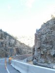
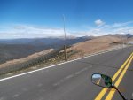
Pix, left to right: 1) Big Thompson Canyon Narrows -- this section of road completely went away in 1976 when the Big Thompson Flood wiped out many of the houses and businesses in the Canyon and killed a bunch of people. Click here to learn more about the flood: http://blogs.denverpost.com/library/2012/07/31/big-thompson-flood-disaster-colorado-1976/2795/
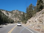
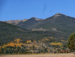
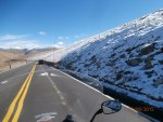
2) Farther up the Canyon on the way to Estes Park. 3) Looking across the Sheep Meadow in RMNP a few aspen are still a'glow. 4) Still above 12,000 feet, a west-facing slope has some of the snow that fell Tuesday night. 5) looking north out of the Park, the mountains west of Cameron Pass are visible.
Know how to stop a line from moving? Put me in it. All ten of the vehicles in the long line got in before we did, plus another line opened up just as we got to the ticket booth.
It didn't hurt anything, because we were through most of the traffic pretty quickly. When we got up to Many Parks Curve, the speed limit was down to 35mph and there was an occasional driver doing 25, but the scenery made it easy to poke along. By the time we got past Rainbow Curve and above tree-line, we were able to run 35 (plus a couple or three miles-per-hour) until we were past the Alpine Visitors Center, which is just a few miles past the high point of Trail Ridge Road, which was, IIRC, 12,210'. The road through the park has been freshly repaved and was a wonderful ride. After we got through the Park, we rode to Granby, and hopped onto US-40, but only for a few miles till we turned north on CO-125, the road to Rand and Walden. 125 is a great road, with sweepers that can be comfortably ridden at 50-60mph speeds. There's an occasional tighter turn that keeps you on your toes until you get to Jackson County a few miles past Willow Creek Pass. Then the road straightens out and has rollers with ranches on the west side and forests on the east side.
Rand is a tiny town with a post office and a General Store and the Rand Yacht Club (which is an occasionally-open eatery. Parked next to the Yacht Club is the entire Rand PD, a bedraggled-looking dummy in an even-more-bedraggled-looking Bronco from the early 70s. That particular vehicle is famous in Iron Butt Rally lore. In 2007 (again IIRC), the bonus location list for Leg 2 was handed out at 6AM. Most riders went to their rooms to fire up the computers and plan the best rides possible. One rider, Jim Owen (who won the Big Sky "Working on the Railroad" Rally this summer with a point total that was 110 more than my miserable 8100 points) looked at the list and went to his room to get his riding gear. He was out of the parking lot by 6:10. He had noticed a huge bonus that had to be gotten during daylight hours. He made it from Ojaia, CA, to Rand, CO, in something like 15 hours. It was only 1,092 miles and it was enough to earn him the win, since it was bookended by ten other days of incredible riding and planning.
Larry and I thumbed our nose at the Rand Cop and boogied it on to Walden, where we ate a great hamburger at the Rock River Inn before heading toward the barn. We had ridden 186 miles at speeds ranging from loiter nominal to "brisk." I put in 4.177 gallons for a commendable 55.6mpg. Larry, on his NC700, put in just under 2.1 gallons for a miserable 88.7 mpg. In addition to his great gas mileage, he didn't seem to have any trouble keeping up with me on my much-more powerful NT. Today's ride definitely made me reconsider the possibility of the NC being a potential successor for the NT. If it weren't for chain maintenance...
As we left Walden, we could see dark clouds looming over the mountains on the north end of RMNP and Cameron Pass. As we started down Poudre Canyon, it was about 40F at the top of Cameron Pass (10,206') and the wind started blowing from the north. By the time we were down to 8,000' we were riding in occasional light showers, but the road stayed fast. Poudre Canyon is the road I had led junglejim and his friend Mitch up when they were here at the beginning of September. There were some spectacular aspen in the upper Canyon, but I didn't get any pictures. My excuse is that Joanne and I were scheduled to conduct the Bingo game at the Senior Living Center where she's been volunteering. My drop-dead get-home time was about 6:00 and the GPS had predicted 6:09 when we left Walden.
We gained quite a bit of time and when we got to Ft Collins, the Garmin was predicting 5:40. But then we hit the traffic jam caused by the detour around the construction on CO-14. I got home at 5:55 and we made it to Bingo.
I had noticed during the traffic jam that my right Denali was apparently out. That kind of chapped me because it was the right one that Twisted Throttle had replaced in August of 2013, toward the end of my Epic Ride. They're s'posed to last longer than that! When we got off if I-25, Larry pulled up alongside and I said, "My right-side driving light is out." He said, "I noticed it shining on the road." I leaned out and turned the wheel to the right. I could see the Denali shining on the pavement and assumed the mounting bracket had come loose and let the light rotate forward when I'd hit a substantial bump as we got to Ft Collins. Then as I turned off of 34 a few blocks from my house, I realized that it was simply hanging from its power cord. I just kept going, figuring that if it was still working after 15 miles at 60-75mph on I-25, it would probably last till I got here. Since I'm leaving for Steamboat early Tuesday morning, I started plotting on how quickly TT could get me a new bracket. Maybe if I called them at 9AM EDT, it could get shipped tomorrow and get here by Monday. But maybe not...
When I got here, it turns out that the bracket had fatigued and broken. After we got home from Bingo, I called Larry (who has a much larger share of mechanical aptitude than I do, and he's going to try to fabricate a replacement bracket after he gets home from work tomorrow. Larry's a heavy crane operator who loads and lifts wind turbine components. He can only work 30 hours/month, but he's working tomorrow, Saturday, and Sunday, and leaving on a vacation with his wife early Monday morning. So, I've got my fingers crossed. I have thought of a back-up if Larry can't get'er done.
Pix, left to right: 1) Big Thompson Canyon Narrows -- this section of road completely went away in 1976 when the Big Thompson Flood wiped out many of the houses and businesses in the Canyon and killed a bunch of people. Click here to learn more about the flood: http://blogs.denverpost.com/library/2012/07/31/big-thompson-flood-disaster-colorado-1976/2795/
2) Farther up the Canyon on the way to Estes Park. 3) Looking across the Sheep Meadow in RMNP a few aspen are still a'glow. 4) Still above 12,000 feet, a west-facing slope has some of the snow that fell Tuesday night. 5) looking north out of the Park, the mountains west of Cameron Pass are visible.
Attachments
-
 163.1 KB Views: 30
 -
 169.8 KB Views: 29
 -
 163 KB Views: 28
 -
 166.8 KB Views: 28
 -
 156.6 KB Views: 30
Last edited:

