If you read my posts, you know that I've had frustrations with my $499 Garmin Zumo XT. I realized it wasn't working right when I rode to St. Francis, KS, to meet Mike Simmons to begin our ride to the NT/ST Rally in Spearfish. Before I got to St. Francis, 160 miles from Greeley, I was seeing a message that said something like "External power has been lost..." By the time Mike and I were back to Wray, about 50 miles from St. Francis, the GPS was out of juice and wasn't working.
I charged it overnight and made it most of the way to Crawford, NE, where I was meeting Jim Moore (Mike had been sick and headed home to Missouri). Again, it wasn't long after Jim and I left Crawford, that it started showing the message again. By Spearfish, it was dead as a doornail. I called Garmin from the motel and the tech I was talking to wanted me to take the power cord out of the mount, but some engineering genius at Garmin had decided that their previous power cord system which had worked great for me with two different Zumos and a cheapy that I used in Joanne's car could be improved. They used the world's smallest Phillips head screw to anchor the power cord to the mount and I didn't have a screwdriver that would work. I charged the GPS and it worked about halfway home to Greeley.
I had the same kind of experience on my way to Spokane and back on my trip to do the trade of Dudley for Horse. I spent some time with a different Garmin tech and he told me that they'd been having some problems with the mount not holding the Zumo steady and they'd also had some issues with the power cord. He said he'd send me replacements. The mount came in 4-5 days, but there was a note saying that power cords were not available. Garmin's power cord supplier was in Germany and they were backlogged. They told me that power cords would be available after October 23rd!!! I expressed my dissatisfaction with something as basic as a power cord keeping a $499 GPS from working and the guy I was talking to commiserated with me, but of course, there wasn't really anything he could do to help.
I changed out the mount and could tell that the new one had a much tighter grip on the GPS. I was hopeful that the new mount would solve my problems and was feeling optimistic when Ken Malone and I joined the MSTA mountain ride a few weeks ago. But just as we got Estes Park, there was the dreaded external power message again.
But Garmin came through early! I got the new power cord from them on Saturday, 13 days before they had even expected to get it. I installed the power cord on Sunday and then today decided to take a longer ride to test it.
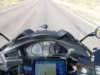
I left Greeley at noon, and rode to Brush, turning south on CO-71 and rode to Last Chance. From there I went east on US-36. Last Chance got it's name (I think) because for many years it was the last place you could buy gas before Kansas. No more. Last Chance has nearly expired. There's a United Methodist Church that manages to hang on, but not much else. Not too long after I left Greeley, the wind which had been predicted to be 4-7mph all day showed up. As I was going south on 71, I was watching my gas gauge drop rapidly and knew that I wouldn't make it to Wray (207 miles from home). My Zumo, which was working (and showing that it was connected to external power!!) told me that there was gas at Anton and at Idalia. I stopped at Anton, where I met the most complicated credit card payment system I've ever seen. I finally figured that out and headed on east. The wind just got stronger and stronger.
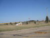
I rode through Joe's, which has a roadside park and liquor store. Joes is sorta' famous in Colorado because in 1929, they decided they wanted to field a basketball team. They suited up 10 kids and their coach learned the rules of the game and they worked their butts off and ended up taking 3rd place in the National basketball tournament! Here's their roadside park:
When I got to Idalia, the gas station was closed and decrepit...but it turned out that there's a new gas station. I could have stopped in Idalia and missed the Anton station's card reader! For a long time, Idalia had a gas station that had been a Texaco station in the 1920s and had been maintained to keep it's original appearance. Not any more.
East of Idalia, I turned north on US-385 and it was amazing. The wind that had battered me for 180 miles became my friend. I know the bike's mpg calculation is really optimistic, but even so, it's cool to be riding 70mph and indicating 70+mpg!
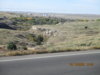
385 has some scenery, something no one would ever say about US-36 for most of the way from Last Chance to Idalia.
When I got to Holyoke, 244 miles into the ride, I had to turn west. That let me enjoy the wind coming from my left instead of my right. I stopped for gas in Sterling and then was on good ol' Colorado 14 until Briggsdale. By the time was 25 miles east of Briggsdale, I was watching the sunset over the Front Range of the Rocky Mountains. You could see smoke coming from the Cameron Peak fire, northwest of Ft. Collins, and there was other smoke, probably from California. By the time I turned for home at Briggsdale, my eyes were burning.
One thing Frosty had told me was that he had never ridden in the dark. If he had, he would have realized that the bike's headlights need adjusting! They're like Dudley's were for quite a while -- aimed too high. I'll take care of that tomorrow.
I got home at 7:15, after 393 miles. And through it all, my Zumo worked flawlessly!! I'm so excited!!
Here's a link to the Spotwalla track of the ride: https://spotwalla.com/tripViewer.php?id=24ae15f8674c07914b
Thursday, I'm riding to Colorado Springs to see my son and daughter-in-law and their new house. Friday morning, I'll meet a group of MSTA riders at Apex Sports, one of the best motorcycle dealerships in the state, and we'll head south towards Bishop's Castle and Westcliffe. I'll get over 6,000 miles for the year -- not as much as some years, but more than I thought I'd get!
Stay safe!
I charged it overnight and made it most of the way to Crawford, NE, where I was meeting Jim Moore (Mike had been sick and headed home to Missouri). Again, it wasn't long after Jim and I left Crawford, that it started showing the message again. By Spearfish, it was dead as a doornail. I called Garmin from the motel and the tech I was talking to wanted me to take the power cord out of the mount, but some engineering genius at Garmin had decided that their previous power cord system which had worked great for me with two different Zumos and a cheapy that I used in Joanne's car could be improved. They used the world's smallest Phillips head screw to anchor the power cord to the mount and I didn't have a screwdriver that would work. I charged the GPS and it worked about halfway home to Greeley.
I had the same kind of experience on my way to Spokane and back on my trip to do the trade of Dudley for Horse. I spent some time with a different Garmin tech and he told me that they'd been having some problems with the mount not holding the Zumo steady and they'd also had some issues with the power cord. He said he'd send me replacements. The mount came in 4-5 days, but there was a note saying that power cords were not available. Garmin's power cord supplier was in Germany and they were backlogged. They told me that power cords would be available after October 23rd!!! I expressed my dissatisfaction with something as basic as a power cord keeping a $499 GPS from working and the guy I was talking to commiserated with me, but of course, there wasn't really anything he could do to help.
I changed out the mount and could tell that the new one had a much tighter grip on the GPS. I was hopeful that the new mount would solve my problems and was feeling optimistic when Ken Malone and I joined the MSTA mountain ride a few weeks ago. But just as we got Estes Park, there was the dreaded external power message again.
But Garmin came through early! I got the new power cord from them on Saturday, 13 days before they had even expected to get it. I installed the power cord on Sunday and then today decided to take a longer ride to test it.
I left Greeley at noon, and rode to Brush, turning south on CO-71 and rode to Last Chance. From there I went east on US-36. Last Chance got it's name (I think) because for many years it was the last place you could buy gas before Kansas. No more. Last Chance has nearly expired. There's a United Methodist Church that manages to hang on, but not much else. Not too long after I left Greeley, the wind which had been predicted to be 4-7mph all day showed up. As I was going south on 71, I was watching my gas gauge drop rapidly and knew that I wouldn't make it to Wray (207 miles from home). My Zumo, which was working (and showing that it was connected to external power!!) told me that there was gas at Anton and at Idalia. I stopped at Anton, where I met the most complicated credit card payment system I've ever seen. I finally figured that out and headed on east. The wind just got stronger and stronger.
I rode through Joe's, which has a roadside park and liquor store. Joes is sorta' famous in Colorado because in 1929, they decided they wanted to field a basketball team. They suited up 10 kids and their coach learned the rules of the game and they worked their butts off and ended up taking 3rd place in the National basketball tournament! Here's their roadside park:
When I got to Idalia, the gas station was closed and decrepit...but it turned out that there's a new gas station. I could have stopped in Idalia and missed the Anton station's card reader! For a long time, Idalia had a gas station that had been a Texaco station in the 1920s and had been maintained to keep it's original appearance. Not any more.
East of Idalia, I turned north on US-385 and it was amazing. The wind that had battered me for 180 miles became my friend. I know the bike's mpg calculation is really optimistic, but even so, it's cool to be riding 70mph and indicating 70+mpg!
385 has some scenery, something no one would ever say about US-36 for most of the way from Last Chance to Idalia.
When I got to Holyoke, 244 miles into the ride, I had to turn west. That let me enjoy the wind coming from my left instead of my right. I stopped for gas in Sterling and then was on good ol' Colorado 14 until Briggsdale. By the time was 25 miles east of Briggsdale, I was watching the sunset over the Front Range of the Rocky Mountains. You could see smoke coming from the Cameron Peak fire, northwest of Ft. Collins, and there was other smoke, probably from California. By the time I turned for home at Briggsdale, my eyes were burning.
One thing Frosty had told me was that he had never ridden in the dark. If he had, he would have realized that the bike's headlights need adjusting! They're like Dudley's were for quite a while -- aimed too high. I'll take care of that tomorrow.
I got home at 7:15, after 393 miles. And through it all, my Zumo worked flawlessly!! I'm so excited!!
Here's a link to the Spotwalla track of the ride: https://spotwalla.com/tripViewer.php?id=24ae15f8674c07914b
Thursday, I'm riding to Colorado Springs to see my son and daughter-in-law and their new house. Friday morning, I'll meet a group of MSTA riders at Apex Sports, one of the best motorcycle dealerships in the state, and we'll head south towards Bishop's Castle and Westcliffe. I'll get over 6,000 miles for the year -- not as much as some years, but more than I thought I'd get!
Stay safe!
")