New Farkle

mikesim

Site Supporter
Joined
Jun 7, 2011
Messages
3,363
Age
74
Location
Union, MO
Bike
NT700, Red, #989,
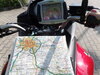
I ran across a new Farkle yesterday that I thought was interesting and useful. I use a Garmin GPS Zumo 595 which is a dedicated motorcycle unit that is truly waterproof and also has in internal TPMS system which I really like. I recently learned that Garmin no longer offers the TPMS sensors so when mine shoot craps I will need to find an alternate system. Also after all these many years the display on the unit is faded badly after a 24/7 duty cycle.

Here is a dedicated motorcycle GPS display system that like the Garmin is truly waterproof. It uses a different approach to functionality however. Instead of having each function integral to the display unit, it uses your favorite apps from your phone via bluetooth. I know many of you use your phone and Google Maps for navigation and so did I at first but a standard auto GPS is not waterproof and covering it up with a Ziploc bag seldom keeps it high and dry.

This new system will use a TPMS app from your phone, along with weather, Waze, music, GPS mapping, cell phone, voice dialing, Bluetooth to helmet comm, etc., pretty much anything on your phone using Android Auto and also Iphone.

CarPlay Lite C5 | Motorcycle GPS Carplay/Android Auto - Ottocast – OTTOCAST

Whatcha think?

Mike
 

Moto-Kafe

Site Supporter
Joined
Jul 16, 2021
Messages
115
Age
69
Location
Pelham (B'ham), Alabama
Bike
2010 Red NT700V
Mike............what if one is in an area without cell service?? Does the GPS "go down" as well.......I would think so?? I ran into this a few times in Canada/Alaska this past summer.
 
OP
OP
mikesim

mikesim

Site Supporter
Joined
Jun 7, 2011
Messages
3,363
Age
74
Location
Union, MO
Bike
NT700, Red, #989,
I don't understand all I know about cellphone GPS, but I believe the cell phone communicates directly with the satellites without regard to the cell signal thus you will always have gps readout. Someone pls correct me if I am wrong.
 
OP
OP
mikesim

mikesim

Site Supporter
Joined
Jun 7, 2011
Messages
3,363
Age
74
Location
Union, MO
Bike
NT700, Red, #989,
Moto, I just did a bit of research on your query, and yes, my understanding of cellphone/gps functionality is correct. I phone and Android phone gps will function correctly without a cell phone signal. Google is your friend.
Mike
 

Fieroguy

Site Supporter
Joined
May 9, 2012
Messages
154
Location
Milford, PA
Bike
2010 Silver NT700
Apple Car Play for the motorcycle? Without having to buy one of those $27K bikes to get it??? Only $250? And can also be used in my pre-Apple Car Play car? This is genius.

Okay, who's gonna be the Guinea Pig and order one from Hong Kong and give us a complete review? Let us know how it goes, Mike! ;)
 
OP
OP
mikesim

mikesim

Site Supporter
Joined
Jun 7, 2011
Messages
3,363
Age
74
Location
Union, MO
Bike
NT700, Red, #989,
I'm doing some more research on the company before I spring for anything. One item of concern for me is there 30 day money-back guarantee. I would hope that there is a longer warranty than 30 days. I will update info as I find it.

Mike
 
OP
OP
mikesim

mikesim

Site Supporter
Joined
Jun 7, 2011
Messages
3,363
Age
74
Location
Union, MO
Bike
NT700, Red, #989,
I emailed 'em yesterday to ask about a US sales agent and what warranty was offered beyond their 30 day moneyback period. I have not heard back from them yet. If it does what they say and it is a reputable firm, their product answers a lot of needs of the motorcyclist.

Mike
 

ST1100Y

Site Supporter
Joined
Nov 7, 2020
Messages
600
Age
59
Location
Vienna, AuSTria, Europe
Bike
ST1100Y, ST1100R, NT700
Dunno...
Navigation wise I see the phone/car apps suitable as plain address-finders but hardly useable for serious touring...
I do all pre-planing on MapSource, load those on the Garmin, nicely sorted in commencing numbers and go...
This maintains redundancy: phone, route plotting, navigation, radio/coms, tunes... all has it's designated device...
 

DirtFlier

Site Supporter
Joined
Dec 13, 2010
Messages
3,341
Location
Troy, OH
Bike
2010 Silver NT700V/ABS
Similar to ST1100Y, I use a Garmin with routes either developed on Mapsource or BaseCamp. At least for me, the major problem with getting a non-Garmin GPS is my loss of backup since our club (MSTA) has tons of "institutional knowledge" about Garmin. Those who've tried other brands, such as Tom-Tom or Lowrance, are hard pressed to find any help at an event when they run into a problem.

ps. A club pal mentioned to me that it was possible to update my ancient Mapsource 2006 with newer maps so I did it and now it has 2023.2 maps! In all honesty, I think most of the map upgrades are mainly changes to non-road items such as gas station locations, new hotels, etc., because the roads don't change too often. :)
 

DirtFlier

Site Supporter
Joined
Dec 13, 2010
Messages
3,341
Location
Troy, OH
Bike
2010 Silver NT700V/ABS
My Garmin 590/w 2023 maps shows roundabouts as a normal intersection with a slight jog in the center - no big deal.
 
OP
OP
mikesim

mikesim

Site Supporter
Joined
Jun 7, 2011
Messages
3,363
Age
74
Location
Union, MO
Bike
NT700, Red, #989,
My preference is also Garmin but they seem to be abandoning the GPS market as it relates to motorcycle touring. It has got to be tough to sell a full featured Zumo when most people reply on their cell phones. I still am frustrated at Base Camp. My all time fave was MS Streets and Trips.

Mike
 

Phil Tarman

Site Supporter
Moderator
Joined
Dec 12, 2010
Messages
9,369
Age
81
Location
Greeley, CO
Bike
2010 Silver NT700VA (ABS)
MS Streets and Trips was my favorite navigation program, too, Mike. Since roads themselves don't change a lot and where motels were in '13 tends to be where motels, gas stations, restaurants, etc. still are, I've been very happy using MS Map Point which can still be downloaded.
 

DirtFlier

Site Supporter
Joined
Dec 13, 2010
Messages
3,341
Location
Troy, OH
Bike
2010 Silver NT700V/ABS
During my working days, I often used MS Streets & Trips but it has gradually been replaced by other software. I still have my original Streets & Trips DVD (non-GPS version) somewhere!
 

ST1100Y

Site Supporter
Joined
Nov 7, 2020
Messages
600
Age
59
Location
Vienna, AuSTria, Europe
Bike
ST1100Y, ST1100R, NT700
During my working days, I often used MS Streets & Trips but it has gradually been replaced by other software. I still have my original Streets & Trips DVD (non-GPS version) somewhere!
Yep, prior Garmin we had MS AutoRoute Express :cool:
Unbeatable features, still harshly missed in the Garmin plotting softwares:
- profile/scheduler: start/end day, lunch stops, fuel range/stops, arrive at 88:88hrs...
- show POIs in XX km distance along the entire route
You just drag'n'drop the entire round trip (Scotland, Norway etc...) on the screen, and it instantly shows how many days, overnight and fuel stops it'll take you...
The program also "back calculated" when you'd need to leave in order to reach a particular port/ferry in time at the end of the tour...
Unfortunately was the *.axe file format not/never compatible to *.gdb or *.gpx...
 
Last edited:

ST1100Y

Site Supporter
Joined
Nov 7, 2020
Messages
600
Age
59
Location
Vienna, AuSTria, Europe
Bike
ST1100Y, ST1100R, NT700
This is my favorite way of navigation.
I've to agree, old fashioned paper maps are always included out on the road; they're providing the global overview required to plot route/stages properly on my netbook...
the limited graphics in CityNavigator or OSM maps won't cut it...
and it's wise to carry that hard copy backup along in case technology fails you...
 
OP
OP
mikesim

mikesim

Site Supporter
Joined
Jun 7, 2011
Messages
3,363
Age
74
Location
Union, MO
Bike
NT700, Red, #989,
For me, half the fun of taking long motorcycle journeys is the preparation. For this, there is nothing better than a paper map... (there is my Ludditeness showing again :thumb:) I usually spend hours going over the road atlas exploring route alternatives. At the motel each night, I break out the atlas once again and review my planned route for the next day. Once on the road however, nothing beats the instantaneous view of the GPS. It can route you around traffic, show local attractions, fuel stops etc. I rely on both to navigate a successful voyage.

Mike
 
Top Bottom