OK. I confess. I took a nap yesterday afternoon instead of riding, but I tried to make up for it today. I left Steamboat at 1:00 and rode west on US-40 to Twentymile Road (CR-27) just east of the Yampa Valley Regional Airport. There were big additions going on at the power plant close to the airport. There are several powerplants between Steamboat and the area around Craig. There's lots of coal mining, open pit and underground, and I'm guessing it's cheaper to push electricity down power lines than it is to haul it on trains.
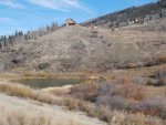
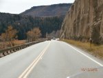
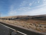
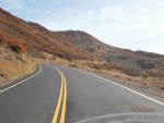
CR-27 is a beautiful road, fresh-paved with freshly-painted lines. In the first 12 or so miles before it gets to the Peabody Energy Company's Twenty-Mile Mine, there are even passing zones. It's a genuinely high-class county road. One gets the feeling that Mr. Peabody demanded some considerations for the huge corporate taxes they're paying. A friend of mine got a tour of the mine several years ago. He knew a guy who was an engineer at the mine and got the tour through him. He said it was about the strangest thing he'd ever done. They were in a Toyota Tacoma pickup and just drove into the mine and proceeded to drive down a straight, steep, sloping road in total darkness for over a mile. His buddy told Bill that they were nearly a mile underground. When they got to the area where the mining was going on, there was plenty of light and lots of big equipment. The coal was lifted to the surface on some kind of conveyer (which you can see in the picture I'm posting here).
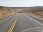
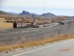
Past the mine, the road continued winding its way to the southwest and the little town of Oak Creek. Five miles south of Oak Creek is Phippsburg, a Union Pacific division point which doesn't seem as busy as it once did. Maybe because they're using the coal to generate electricity close to the mines instead of moving the coal to distant power plants?
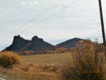
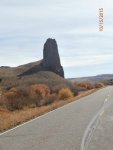
There are interesting geological formations between Phippsburg and Yampa, the next town south on CO-131. I'm guessing that they're volcanic cores but maybe someone on the list will know more than I do.
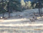
Elk hunters were everywhere. I stopped for a cuppa' in Yampa and saw about 30 hunters...one had a about a 4-point bull, but he was the only one who had gotten an elk out of that bunch.
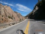
South of Yampa about 10 miles, I turned east on CO-134 heading towards Gore Pass and to US-40 north of Kremmling. More great road, but there were hunters pulling camping trailers and vehicle trailers cluttering up the road. Gore Pass was about 9400' ASL, a couple of thousand feet higher than Toponas where I got on to 134.
I stuck with US-40 through Kremmling, Hot Sulphur Springs, and then turned onto my "home" highway, US-34, where it begins about a mile west of downtown Granby. Riding past Lake Granby, you can see the Indian Peaks to the east and the southern part of the mountains that are enshrined in Rocky Mountain National Park.
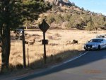
There was no ranger at the entrance to the Park so I didn't get to gloat about my National Parks Pass. But I also didn't have any cars going my way until I got east of the Alpine Visitor's Center up near the top of the Park, so I gloated about that. I think I've mentioned that the speed limit in the Park used to be 45mph, but in the twistier and higher-altitude sections, it's been reduced to 35mph now. Oddly enough, I like the change. I ride at about 37-40mph when there's no traffic and that's fast enough. It seems to me as if there's less congestion since the speed limit was lowered. I did get behind two cars on my way through the Park who were driving 3-5mph under the limit. I just stayed patient until I got to one of the short (and rare) passing zones. The last few miles in the Park were really congested by the crowds who had come to watch the elk during breeding season. With my earplugs and helmet on, I wasn't able to hear any of the bulls bugling. if you've never heard an elk bugle, I'm sure you can google it and hear the sound. It's a very high-pitched warbling sound that ends with a deeper grunting noise. Lots of testosterone in those big guys. They manage to keep a harem of up to 20-40 cows and usually don't have to get physical with the younger, smaller bulls who hang around on the edges of the herd. Just as I got to the east gate, traffic stopped and I could see cows on the road. They were coming out of a thicket on the left side of the road and I finally saw the big bull who was moving them. He was a seven-pointer (that means seven points on each antler, BTW). Just a little further along, there were probably 20 young bulls. Most of them were "spikes" -- one straight antler with no branches (and extra points) that would be between one and two feet high. There were a couple of two- and three-pointers who will be making their moves to oust the big bulls in another couple of years.
From Estes, traffic down Big Thompson Canyon moved right along tonight. Usually there's someone traveling 30mph who doesn't think that they're the "Slow Traffic" that is told to use the turnouts to let backed-up vehicles go around them.
I got home at 6:30, five minutes after sunset, after a really nice 232-mile ride with more than a quarter tank of gas left in the tank.
I sometimes think of riding twisties and sweepers as akin to dancing. I'm not a very good dancer, and there are days when I'm not very good at dancing with the turns. When I was on Twentymile Road, I wasn't very fluid or smooth-feeling, so I just slowed down and enjoyed a very moderate pace. But about halfway up Gore Pass, I got into the "zone," and the dance began. It continued to be very fluid and smooth all the way through the Park and then even better down Big Thompson Canyon. It's a very rewarding feeling when it comes. Good old FalconAF (who is remembered fondly by those of us who have been on the Forum for years) helped me recover the rhythm when we were riding between Ligget and Fort Bragg, CA, back when I was doing my Epic Ride. He could tell that I was struggling and suggested that I might be trying to watch the road right in front of me instead of looking through the turn. I've figured out that looking farther ahead when I'm riding curves helps smooth me out and "dance" more gracefully.
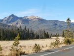
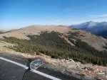
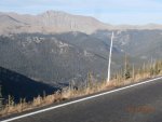
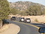
Pictures L to R: 1) The Yampa river had made US-40 a nice ride between Steamboat Springs and Craig, CO. 2) Twentymile Road paved very well and heading for: 3) Mr. Peabody's Coal Mine, which (according to my friend) is more interesting looking under ground than aboveground; 4) Twentymile between the mine and Oak Creek; 5) Phippsburg, between Oak Creek and Yampa with the (presumably) lava extrusions visible in the distance.
More pix in the next post.
CR-27 is a beautiful road, fresh-paved with freshly-painted lines. In the first 12 or so miles before it gets to the Peabody Energy Company's Twenty-Mile Mine, there are even passing zones. It's a genuinely high-class county road. One gets the feeling that Mr. Peabody demanded some considerations for the huge corporate taxes they're paying. A friend of mine got a tour of the mine several years ago. He knew a guy who was an engineer at the mine and got the tour through him. He said it was about the strangest thing he'd ever done. They were in a Toyota Tacoma pickup and just drove into the mine and proceeded to drive down a straight, steep, sloping road in total darkness for over a mile. His buddy told Bill that they were nearly a mile underground. When they got to the area where the mining was going on, there was plenty of light and lots of big equipment. The coal was lifted to the surface on some kind of conveyer (which you can see in the picture I'm posting here).
Past the mine, the road continued winding its way to the southwest and the little town of Oak Creek. Five miles south of Oak Creek is Phippsburg, a Union Pacific division point which doesn't seem as busy as it once did. Maybe because they're using the coal to generate electricity close to the mines instead of moving the coal to distant power plants?
There are interesting geological formations between Phippsburg and Yampa, the next town south on CO-131. I'm guessing that they're volcanic cores but maybe someone on the list will know more than I do.
Elk hunters were everywhere. I stopped for a cuppa' in Yampa and saw about 30 hunters...one had a about a 4-point bull, but he was the only one who had gotten an elk out of that bunch.
South of Yampa about 10 miles, I turned east on CO-134 heading towards Gore Pass and to US-40 north of Kremmling. More great road, but there were hunters pulling camping trailers and vehicle trailers cluttering up the road. Gore Pass was about 9400' ASL, a couple of thousand feet higher than Toponas where I got on to 134.
I stuck with US-40 through Kremmling, Hot Sulphur Springs, and then turned onto my "home" highway, US-34, where it begins about a mile west of downtown Granby. Riding past Lake Granby, you can see the Indian Peaks to the east and the southern part of the mountains that are enshrined in Rocky Mountain National Park.
There was no ranger at the entrance to the Park so I didn't get to gloat about my National Parks Pass. But I also didn't have any cars going my way until I got east of the Alpine Visitor's Center up near the top of the Park, so I gloated about that. I think I've mentioned that the speed limit in the Park used to be 45mph, but in the twistier and higher-altitude sections, it's been reduced to 35mph now. Oddly enough, I like the change. I ride at about 37-40mph when there's no traffic and that's fast enough. It seems to me as if there's less congestion since the speed limit was lowered. I did get behind two cars on my way through the Park who were driving 3-5mph under the limit. I just stayed patient until I got to one of the short (and rare) passing zones. The last few miles in the Park were really congested by the crowds who had come to watch the elk during breeding season. With my earplugs and helmet on, I wasn't able to hear any of the bulls bugling. if you've never heard an elk bugle, I'm sure you can google it and hear the sound. It's a very high-pitched warbling sound that ends with a deeper grunting noise. Lots of testosterone in those big guys. They manage to keep a harem of up to 20-40 cows and usually don't have to get physical with the younger, smaller bulls who hang around on the edges of the herd. Just as I got to the east gate, traffic stopped and I could see cows on the road. They were coming out of a thicket on the left side of the road and I finally saw the big bull who was moving them. He was a seven-pointer (that means seven points on each antler, BTW). Just a little further along, there were probably 20 young bulls. Most of them were "spikes" -- one straight antler with no branches (and extra points) that would be between one and two feet high. There were a couple of two- and three-pointers who will be making their moves to oust the big bulls in another couple of years.
From Estes, traffic down Big Thompson Canyon moved right along tonight. Usually there's someone traveling 30mph who doesn't think that they're the "Slow Traffic" that is told to use the turnouts to let backed-up vehicles go around them.
I got home at 6:30, five minutes after sunset, after a really nice 232-mile ride with more than a quarter tank of gas left in the tank.
I sometimes think of riding twisties and sweepers as akin to dancing. I'm not a very good dancer, and there are days when I'm not very good at dancing with the turns. When I was on Twentymile Road, I wasn't very fluid or smooth-feeling, so I just slowed down and enjoyed a very moderate pace. But about halfway up Gore Pass, I got into the "zone," and the dance began. It continued to be very fluid and smooth all the way through the Park and then even better down Big Thompson Canyon. It's a very rewarding feeling when it comes. Good old FalconAF (who is remembered fondly by those of us who have been on the Forum for years) helped me recover the rhythm when we were riding between Ligget and Fort Bragg, CA, back when I was doing my Epic Ride. He could tell that I was struggling and suggested that I might be trying to watch the road right in front of me instead of looking through the turn. I've figured out that looking farther ahead when I'm riding curves helps smooth me out and "dance" more gracefully.
Pictures L to R: 1) The Yampa river had made US-40 a nice ride between Steamboat Springs and Craig, CO. 2) Twentymile Road paved very well and heading for: 3) Mr. Peabody's Coal Mine, which (according to my friend) is more interesting looking under ground than aboveground; 4) Twentymile between the mine and Oak Creek; 5) Phippsburg, between Oak Creek and Yampa with the (presumably) lava extrusions visible in the distance.
More pix in the next post.
Attachments
Last edited: