Day Three
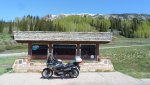
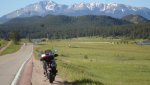
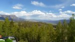
I woke up to the sun peaking over the mountain to the east of the town of Delta. Not a cloud in the sky and the air had been washed the night before with the thunder storms that rolled through. As I eat my breakfast I keep looking out the window watching the sky turn from a night time gray to the most beautiful blue one can imagine. Today had the promise of being one of those story book chambers of commerce Colorado days. I was packed and on the road by 0630am. It really does pay to be up and out riding very early in the morning.
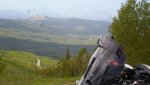
Today was the last day of my three day loop through Colorado, and it had the promise of being the best. Don’t get me wrong, any day riding in the high country of Colorado is great, but some days things just seem to come together to make that day magnificent. Such was today. As I said in my previous post, my first goal of today was to ride hiway 133 past Paonia
and take county road 12 over
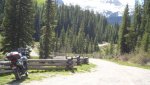
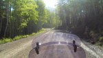
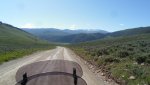
Kebler Pass (9980ft). This county road is dirt and gravel, and is very easy and smooth when dry.
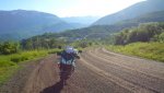
If can get a bit muddy and very slippery when it is wet or raining. Not fun. Today the road was damp and in spots it had its share of mud. Just wet enough that the tires and weight of the bike would squeeze the water out of the wheel tracks. The mud was only an issue where the gravel was a bit thin. The county road crews had been up there dropping/spreading a lot of gravel on the road as to minimize the slippery muddy conditions.
One of the view days I look forward to more gravel. Remember, Colorado has had a nice wet spring with a massive amount of snow melt/run off, here in the last couple of weeks.
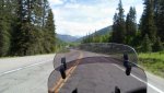
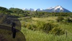
This route is about 30 something miles long and runs through some beautiful Aspen groves. I love the early morning sun peeking through the Aspen trees.
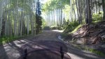
The early season Aspen leaves are just a beautiful light, glistening, green as they are bathed by the rising sunlight.
It is difficult for me to explain the feelings of being alive and very content up here.
Word just can’t describe the natural beauty. You really are just going to have to go see for yourself.
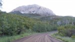
As I said Kebler Pass spits you out at the back side of
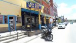
Crested Butte (elevation 8908ft). Great little town that lies in the shadow of Mt. Emmons (12392ft).
Full of art galleries, Fu Fu coffee Shops, and lots of young pretty girls. Compared to me all the girls are young, but I digress. I decide to stop and warm up a bit in the morning sun as the crossing of Kebler was a bit chilly. Found me a coffee shop and paid too much for a cup of coffee. Sat outside the shop and struck up a conversation with one of those young girls. Found out that the Pass had only been opened for travel the day before.
Well it was time to go, so I made a loop around town, looking at some of the sights and then headed down hiway 135. Big wide smooth road.

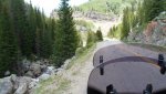
I remember the last time I rode into Crested Butte, 20 years ago, this road was just a little rough narrow two lane. I guess that is progress. Had to find the Jacks Cabin turn off, forest service road 813
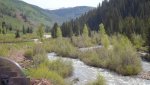
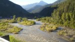
which cuts over to Forrest service road 742 going up the Taylor river to Tayler Reservoir. Well there is nothing very forest service about this road 742 anymore. Used to be dirt the first time I rode it back in the early 90’s. Today it is a beautiful paved narrow two lane with orgasmic twistys and curves.
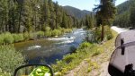
The Wee was just screaming with ecstasy as we traversed the corners. I really needed to slow down as the views along the rushing river were diverting my attention from the road.
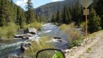
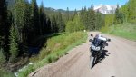
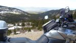
Had I had the time I would have run that stretch of road back and forth two or three times. But onward. My next goal was to find the back side of Cottonwood Pass and head up over the dirt road to the summit.
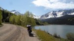
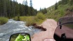
Got to Tayler Park Reservoir
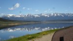
without crashing and let the GPS help find County Road 209 which winds its way up the west/backside of Cottonwood Pass. However there is a little town about 6 mile south of the reservoir called
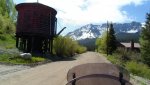
Tin Cup. Haven’t been there since by BMW GS days 18 years ago. Rode down to Tin Cup for a picture
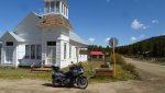
and found that Tin Cup has not changed a bit in the last 20 years, So back to Taylor Park Reservoir. This area has become the playground for the ATV groups. Most of the campers and ATV folks drive up over Cotton Wood from the east side and down the west/dirt side.
One has to be very careful riding up the west side of the pass, as it will be likely the a meeting of a large pickup pulling a 30+ft camping trailer, with a couple ATVs hanging off of it. They will be barreling down just around the bend. Gotta stay to the right as much as possible. Of course there are no guard rails.
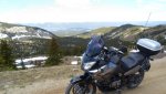
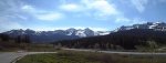
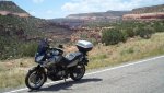
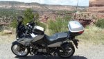
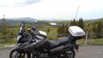
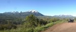
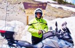
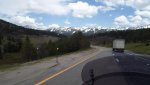
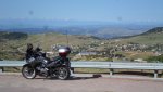
Onward and upward. The climb up to the summit of Cottonwood (Pass 12126ft) went without incident.
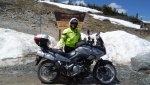
Again a wonderful ride. I don’t think there is a bad ride any were west of I-25 except for Down Town Denver. Got to the top and just enjoyed the majestic
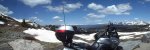
views and got a couple more pictures of myself in front of the summit sign.
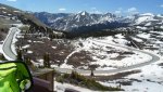
The paved road down the east side is smooth and full of twists and turns and is a joy to ride on a light bike like the WeeSTrom. Being that it was during the week and relatively early in the day, not too much traffic and only two cares in front of me. They pulled over and let me by.
These kinds of roads and rides are more fun than the roller coasters at Six Flags. And a lot prettier views. Got down to the bottom and took a county road 361 which by passed Buena Vista to the west and spits out onto State Hiway 24. One to Leadville for lunch at the
Golden Burro.
The Golden Burro is one of the town’s favorite eating establishments, and I have been stopping there for years, when I travel through Leadville. But because of its popularity, it is becoming a bit commercialized and more crowded. But then again, so is the entire State of Colorado west of I-25 Interstate.
My master route was to ride out hiway 91 over Freemont pass (11318ft) and it the interstate I-70 east, and then up over Loveland Pass. But I chose to go 24 to
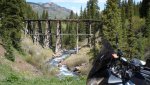
Red Cliff and get just a bit more dirt riding in. At Red Cliff there is a short cut that goes around the back side of Battle Mountain and misses the climb up and over Vail Pass on the freeway. This short cut is FS roads 708,709,712.
I traverse this road a couple of years ago. It goes over
Shrine Pass(11089ft) and comes out on the east side of Vail Pass and has a magnificent view of I-70 snaking its way through the mountains. So off I went. Got back about two miles and there is a gate that was not there before, and signs saying no vehicular entry, old military training area. Also it said that hikers were to leave stray ammunition alone, if found. I guess the 10th Mountain Division use to train in that area during the WWII years, and some hiker found some old ordnance. I am just guessing on this, will have to research the how’s and whys. Bummer. Had to retrace my tracks
and head north on 24 to Minturn and hit the Freeway for the ride over
Vail Pass and the
Eisenhower Tunnel on I-70. Because of this delay I did not have time to ride over
[URL="http://en.wikipedia.org/wiki/Loveland_Pass"] Loveland Pass[/URL] on old hiway 6. That is OK because I will get a chance for that on Saturday’s ride to eat in Dillon.
So on the Freeway, I am and headed home. My Three Day Colorado loop is coming to an end. I would be remiss if I did not say I was a bit sadden that this ride was at it’s end. However I live here and this is all in my back yard. I will just start doing more overnight rides instead of just day rides.
Total mileage for the Day was about 350 miles and total mileage for the Three Days was 1182 miles. I believe this route took in most of the type of scenery and riding condition that Colorado has to offer. The route can be modified slightly, to bypass the dirt and stay on pavement, However the WeeSTrom type adventure bike is the kind of bike to tour the High Country. And if you really want to get into the Back Country , a Dual Sport ie; KLR, DR650, or smaller dirt bike, etc. is the bike to ride.
Had a great time, can’t wait to GO RIDE again.
 down just west of Canon City
 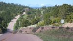 and run west on hiway 50 along the Arkansas River to a small hamlet called Coaldale. I was to put eyes on and inspect a DR650 for a Texas riding buddy of mine. We are planning to ride the Continental Divide Trail from northern Colorado to Deming NM. Took me about 4 hours to get to Coaldale. Population 327 or so. From there I rode over Monarch Pass (11312ft)
 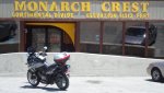 and then on to Gunnison. Turn south onto 149 thru Lake City
 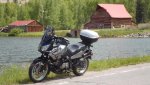 and on over Slumgullion Pass (11351 ft)
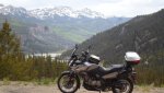
 and then over Spring Creek Pass
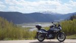
 (10901ft) to the town of Creede.
 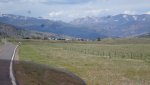 Interesting little town.
 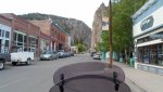 I was running behind schedule so I did not get a chance to explore the town. One interesting note is their fire rescue station is inside of an old mine, cut into te rock of the mountain, that Creede is nestled up to. On from Creede to South Fork and then Hiway 160 over Wolf Creek Pass.(10880ft)
 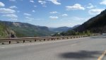 There were some other passes that I went over that were just above the 10kft level, but I don’t remember the names. Then onto Pagosa Springs were I am spending the night in a little motel with character, (read cheap ).
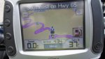
  Total time for today was 11.5 hours to include time looking at the DR. Total miles for today was 430. Follow my spot. Of course here are some pictures of today. So ends day one.